Should we reinvent the way we advise African smallholder farmers?
Development organization professionals from the agriculture, health, education, conservation and humanitarian sectors will gather from April 30 to May 2, 2019 in Kampala, Uganda for the Information and Communication Technologies (ICT) for Development ICT4D conference organized by Catholic Relief Services. The aim of this conference is to explore which digital innovations could accelerate progress towards meeting the Sustainable Development Goals. Jens Andersson, a social scientist at the International Maize and Wheat Improvement Center (CIMMYT), will speak on how we could reinvent advisory services for African smallholder farmers, such as through decision support tools. The following interview reflects his thoughts on the issue.
Q: Some experts say that current agronomic research does not properly advise smallholder farmers. Farmers are given blanket recommendations on key subjects such as crop varieties, fertilizer use and seed spacing. Why do you think that we need to reinvent advisory services?
A: Smallholder farmers with limited resources often can’t afford fertilizer and seed. They also don’t reach agronomic management levels assumed by the blanket recommendations given by agricultural extension services. They may not have enough cash to invest, enough labor to carry out tasks – such as weeding – as frequently as recommended, or they may not prioritize crop production as a part of their livelihood. Consequently, input investments and agronomic management vary considerably from field to field and so does the fertility of those fields. Standard advice simply is not enough, given the diversity of farmers’ situations.
The challenge is to identify the key factors shaping maize yields in farmers’ fields and to identify how a farmer could more efficiently use his or her available inputs and available labor. It is not about telling farmers what to do, but about providing options that suit each farmer’s situation. Technologies such as remote sensing and ICTs can help tremendously in data collection for assessing the conditions of farmers’ fields and better tailoring agronomic advice to their specific situation.
Q: Since 2015, CIMMYT has been working with research, extension and development partners in Nigeria, Ethiopia and Tanzania to develop strategies to Take Maize Agronomy to Scale in Africa (TAMASA). Can you explain the overall approach on how to scale advice to farmers?
A: With ICTs, we can now link and integrate very diverse types of geospatial data, such as soil data, climate and weather data, as well as socio-economic data such as market prices and population densities. Mobile internet and GPS enable us to have such data available for any location. When combined with information obtained from farmers about their field conditions and preferences, agronomic advice can become location-specific.
This approach requires that agronomic data be collected in a geospatial manner. Therefore, TAMASA has conducted numerous agronomic experiments across agricultural landscapes in major maize growing areas in Nigeria, Ethiopia and Tanzania to establish a geographical distribution of soil nutrient availability and fertilizer responses. Such information can be used to model crop responses to fertilizer, and — when combined with fertilizer and crop price information — can provide nutrient recommendations for an individual field through an ex-ante spatial assessment framework. With this approach, extension providers can improve fertilizer recommendations, increasing farmers’ fertilizer use efficiency, productivity and profitability.
For example, in a trial conducted with 435 farmers in Nigeria, using the decision support tool Nutrient Expert resulted in farmers investing more in inputs and agronomic management and doubling their maize yields from 2 to 4 tons per hectare on average.
Q: What digital innovations do you want to showcase at the ICT4D conference? Which type of users are you targeting?
A: Providing location- or field-specific advice at scale requires understanding what information farmers need and what extension services they use. This is probably best illustrated with the example of the Maize-Variety-Selector (MVS) – a mobile phone application developed by TAMASA. Using climate data, information on the growth characteristics of specific maize varieties and multilocational agronomic trials, this application can advise on the most suitable maize varieties for a particular location and for a preferred planting and harvesting date. The application provides options tailored to farmers’ preferences and farming conditions.
Yet, such advice is of limited value in situations where the advised crop varieties are not available in local agro-dealer shops, or when farmers can’t be sure they are actually buying the variety of their choice due to poor packaging and labeling practices, as is sometimes the case in Nigeria.
In addition, government extension services in sub-Saharan Africa are overburdened and not capable of reaching many individual farmers: there is usually only one extension worker for every 2,500 farmers or more.
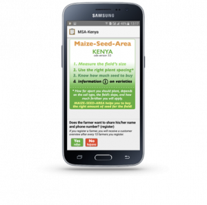
To improve extension outreach in Western Kenya, TAMASA developed a plant density and seed requirement mobile phone application – Maize-Seed-Area (MSA) – in consultation with both extension workers and agro-dealers. Using this application, extension workers reported they could now provide information on specific maize varieties because the application has a built-in database of available maize varieties.

Experiences of agro-dealers were different, as some found that their customers had made up their minds about what variety to buy before entering an agro-dealer shop. Agro-dealers reported that their customers particularly liked the seed requirement calculator, which provides immediate advice on how much seed to buy of a particular variety. In a phone survey, farmers indicated that they trusted the agro-dealers’ advice when it was provided by the mobile phone application.
Q: TAMASA has been exploring the use of decision support tools for large-scale agronomic investments such as country-wide fertilizer subsidy programs. Could you explain your approach to this issue and its potential applications?
A: Some regional soil fertility programs and African governments aim to improve farmers’ yields and incomes through costly, large-scale distribution of fertilizers or soil inputs. Generating more site-specific agronomic recommendations at scale and taking into account the spatial diversity of a landscape, market prices and other supply chain elements will optimize the impact of such operations.
TAMASA has integrated various geospatial datasets such as the ISRIC World Soil Information’s SoilGrids, the World Bank’s Living Standards Measurement Study agriculture dataset (LSMS-ISA), and the Global Yield Gap Atlas. Thanks to the ex-ante spatial assessment framework, we can better target future areas of intervention that currently have low maize yields but could potentially have profitable fertilizer usage.
Mapping predictive yield response and profitability can give us precious insights. For instance, many Ethiopian farmers face acid soils, and the government and development agencies have been thinking about lime distribution at scale to combat this issue. We could potentially create a lime dashboard by adapting the ex-ante spatial framework and provide key information to policymakers at the local and national level.
Q: Are you looking for potential partners at the ICT4D conference to help scale up this work?
A: At the ICT4D conference, we are looking forward to teaming up with new development partners, seed producers and governments to make these field- and farmer-specific advisory applications and decision support tools for agronomic investments more widely available to African smallholder maize farmers.
 Capacity development